- Rating: EF-2
- Location: Dallas, WV
- County: Ohio, Marshall
- Start Time: 7:05 p.m. (40.03, -80.54)
- End Time: 7:09 p.m. (40.01, -80.51)
- Estimated Peak Wind: 111-120 mph
- Path Length: 1.75 miles
- Path Width Maximum: 350 yards
- Fatalities: 0
- Injuries: 0
Details from NWS storm survey: The National Weather Service conducted a storm survey in Ohio, Marshall, and Washington counties. An EF2 tornado was determined based on the visible tree damage. The tornado touched down just west of the end of Sparrow Lane off of Dallas Pike Road where a barn was completely destroyed. In addition, a camper was overturned and destroyed on the property. The tornado continued east knocking down numerous trees along Dallas Pike Road, both hardwood and softwood. Most of the trees that sustained damaged were snapped at the trunk. The storm did tear off the roof of a 160-year-old barn off of Rock Valley Farm Road. Down and snapped trees continued east-southeast crossing into Pennsylvania before it lifted just east of Fraction Road in Washington County. There was a church parsonage that sustained major roof damage off of Dallas Pike Road. The National Weather Service would like to thank Marshall and Ohio County Emergency Management Agency for their assistance today along with the Dallas Volunteer Fire Department.
Photos of Damage
All photos from this storm event are provided by Tom Hart of Cameron, WV. Tap/click here for many more photos he has provided.
Radar Imagery
Panel of storm at time of tornado - click/tap on image for full resolution (Clockwise from top left: Base Reflectivity 0.5 degree, Base Velocity 0.5 degree, NROT 0.5 degree, Correlation Coefficient 0.5 degree)
Base Reflectivity Analyzed
A pretty classic supercell with plenty of features to denote, including the rear flank gust front, forward flank gust front, hook echo, rear flank core, bounded weak echo region (BWER) forward flank core and the tornado itself.
Correlation Coefficient Analyzed
Though the image is a bit noisy, there is a small drop in correlation coefficient values right at the location where gate-to-gate shear is present, perhaps indicating some branches and other pieces of debris being lofted. There is also much smoother yet still a drop in CC values north of the circulation in the forward flank core, which is likely either some small hail or melting hail. No hail reports were received for this storm.
Specific Differential Phase Analyzed

Some moderate values of positive KDP indicated some large rain drop sizes or perhaps some water-coated hail in the storm. The radar is scanning at about 2,300 feet above radar ground level so some hail melting is certainly possible.
Maximum Estimated Hail Size Analyzed
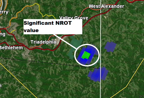
Normalized Rotation Analyzed
Spectrum Width Analyzed
When Spectrum Width is summed, you can clearly see the path of the rotating storm due to the chaotic nature of the particles within the rotation itself:
Vertically Integrated Liquid Density Analyzed
Once again, little evidence of large hailstones as VILD values are on the low side - perhaps some melting hail making it down to the ground, but they would be small stones in size.
The application of ZDR here is quite helpful in seeing this storm. You can see the tornado debris signature with the local minimum grouping of values. In addition, there's likely hail melting north of the circulation in the rear flank downdraft and forward flank core with very high ZDR values, indicating either very large rain drops or some hail mixing in.


