- Rating: EF-1
- Location: 1/2 mile NE of St. Joseph
- County: Marshall
- Start Time: 3:15 p.m.
- End Time: 3:20 p.m.
- Estimated Peak Wind: 100 mph
- Path Length: 1 mile
- Path Width Maximum: 150 yards
- Fatalities: 0
- Injuries: 0
- Damage: $100,000
Details from NWS Survey: On Sunday, April 28th, 2002, seven separate tornadoes occurred in nine different counties across western Pennsylvania and the northern panhandle of West Virginia. This is the most prolific outbreak of tornadoes across our region since June 2nd, 1998. On June 2nd, nine tornadoes crossed the area. About 3:15 pm an EF-1 tornado touched down about one-half mile northeast of the town of St. Joseph in southeast Marshall County. It traveled about 1 mile before dissipating around 320 pm. The estimated maximum winds were about 100 mph with a maximum width of about 150 yds. The tornado destroyed a barn and damaged several others. Shingles were blown from a house. There were numerous trees toppled or snapped. This storm also produced very large hail of up to 2.5 inches in Monroe County, Ohio and baseball size in Muskingum County, Ohio.
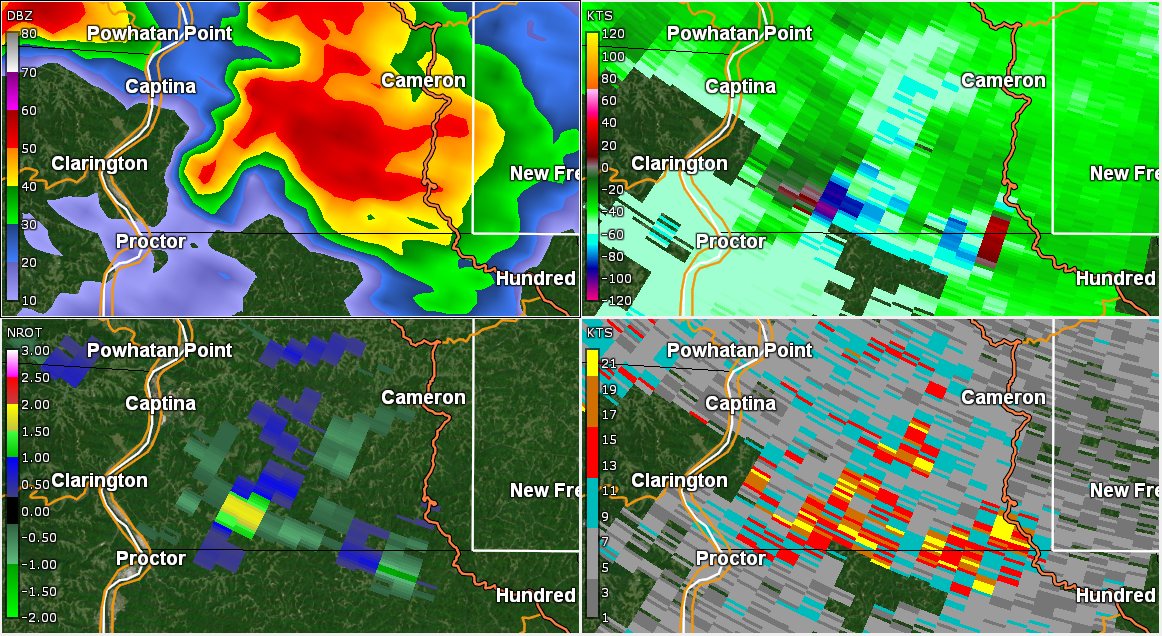
Radar Imagery
Panel of storm at time of tornado - click/tap on image for full resolution (Clockwise from top left: Base Reflectivity 0.5 degree, Base Velocity 0.5 degree, NROT 0.5 degree, Spectrum Width 0.5 degree)
Panel loop - click/tap on image for full resolution (Clockwise from top left: Base Reflectivity 0.5 degree, Base Velocity 0.5 degree, NROT 0.5 degree, Spectrum Width 0.5 degree):

Base Reflectivity Analyzed


Base Velocity Analyzed


Normalized Rotation Analyzed

At 3:11 p.m., NROT values were quite substantial, peaking at 1.84 near St. Joseph. But by the next radar scan at 3:16 p.m., this value dropped by half to a peak of 0.93. The summed NROT product below easily shows the rotation of this storm as it enters and continues through southern Marshall County.


Again, the lack of resolution of this data from 2002 makes this storm a little more difficult to analyze, but a couple of characteristics can still be denoted, including the chaotic flow of particles from the tornado itself at 3:11 p.m., as well as the turbulence of the inflow of the storm. I included the sum product of Spectrum Width below, but there's not much to gather from this piece of information, considering the granular nature of the data.
